
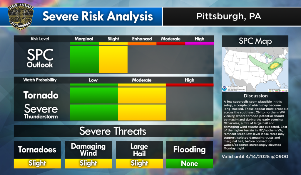
Slight Risk for severe weather 4/14/25
Summary
A couple tornadoes along with scattered damaging winds and large hail are possible from mid-afternoon to mid-evening across parts of the Upper Ohio Valley and central Appalachians.
Synopsis
Day time heating will be a big factor playing into the intensity of the system. There is discrepancy between the models on the degree of heating Monday afternoon. That with a lower confidence of moisture are a mitigating factor in a category upgrade to an enhanced risk.
If robust daytime heating occurs, MLCAPE values may be near 1000 J/kg. Presence of the elevated mixed level (EML) may delay storm development into the mid afternoon timeframe. An intense mid-level jet will support fast-moving convection, along with effective bull shear above 60 kts. Low-level hodograph curvature should be moderately enlarged.
A few supercells seem plausible in this set up. Highest potential for severe weather with all hazards will most likely be in the SE Ohio/N West Virginia/Extreme SW Pennsylvania region. Tornado threat will be maximized in the early evening. Throughout the event, a threat for large hail and damaging winds will be present. Convection should wane and/or become increasingly elevated Monday night.
Individual risks
Categorical: SLIGHT
Tornado: 5% SE Ohio, NW West Virginia, Extreme SW Pennsylvania.
Wind: 15% SE Ohio, Northern West Virginia, Eastern Maryland, NE Kentucky.
Hail: 15% SE Ohio, Northern West Virginia, Eastern Maryland, NE Kentucky
Leave a Reply