
Key Points
A flooding and severe thunderstorm risk is likely to impact the area today through the weekend.
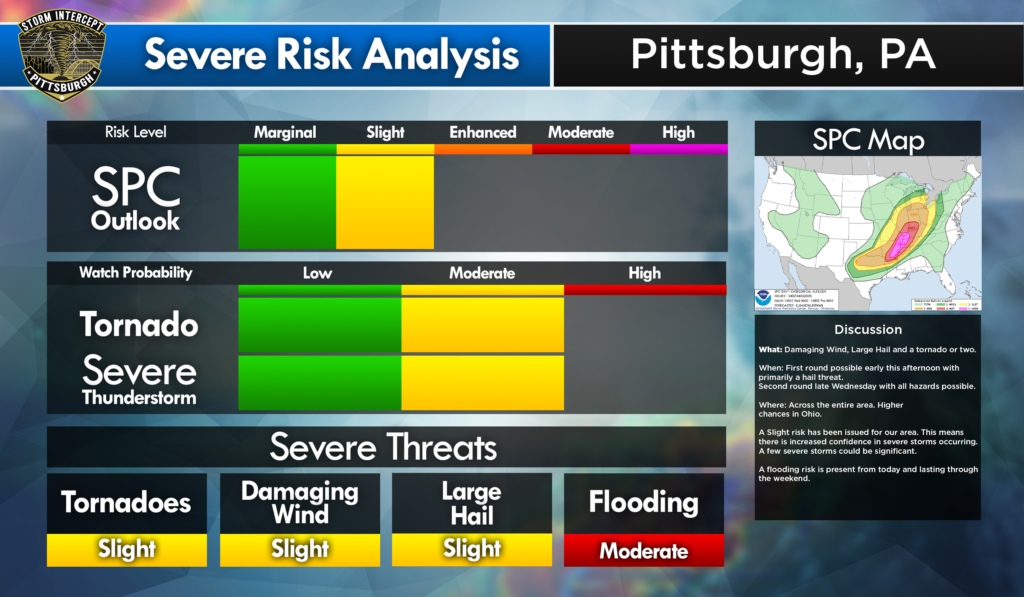
A Slight Risk Means:
There is increased confidence in severe storms occurring.
A few severe storms could be SIGNIFICANT*.
*Significant is defined as: Gusts >75mph, Hail >2″, and/or Tornado EF-2 or greater/
Severe Risk
When: Today into Thursday.
What: All Hazards. Early afternoon today primarily hail threat. Late tonight will have all hazards.
Where: Higher chances as you go west through Ohio today and south of the I-70 Corridor tomorrow.
Actions: Monitor the latest forecasts from trusted sources. MAKE SURE YOU CAN RECEIVE WATCHES AND WARNINGS!
Flooding Risk
When: Today through the weekend.
What: Multiple days of heavy, soaking rain. Localized flooding and rising rivers and streams are likely.
Summary
Early this afternoon storms will begin and will bring primarily a hail threat. This evening storms will bring all hazards. A Flooding risk is present for the rest of the week into the weekend. Higher risks as you go WEST through Ohio, but risk is still present in western Pennsylvania. Stay updated by following us on our social media accounts. We will update throughout the day and evening on our social media.
Leave a Reply